
Boundaries change frequently, and one has to account for that when comparing data across time. This blog post explains how IPUMS-I approaches the task of mapping historical boundaries.
Overview
- IPUMS International disseminates census microdata for Nicaragua in 1971, 1995 & 2005.
- Data are available for departments (primary administrative unit) and municipalities (second administrative unit).
- Boundary maps from the most recent census are readily available, but older maps like those from the 1971 need to be constructed. Due to numerous boundary changes, it is not always possible to recreate older administrative divisions based on the most current map—sometimes we have to look further in the past.
According to the 1971 Census of Nicaragua, the country was divided at that time into 127 municipalities. However, there was no map for 1971 and the maps available for 1995 and 2005 showed 145 and 154 municipalities, respectively—not 127, as in 1971. We had to identify what changes had occurred in the administrative division of Nicaragua during the 1971 to 1995 period and recreate a map that matched the 1971 census microdata.
Our sources were the historical census volumes of the National Census of Dwellings and Population published by the National Institute of Statistics and Censuses in Nicaragua. The available published maps were from 1995 and 1963—not 1971. After scanning and aligning the historical paper map of 1995 to the recent digital map from 2005, we were able to recreate digital boundaries for 1995. Next was the challenging job of creating the 1971 boundaries from the newly created digital boundaries of 1995 and the older paper map from 1963.
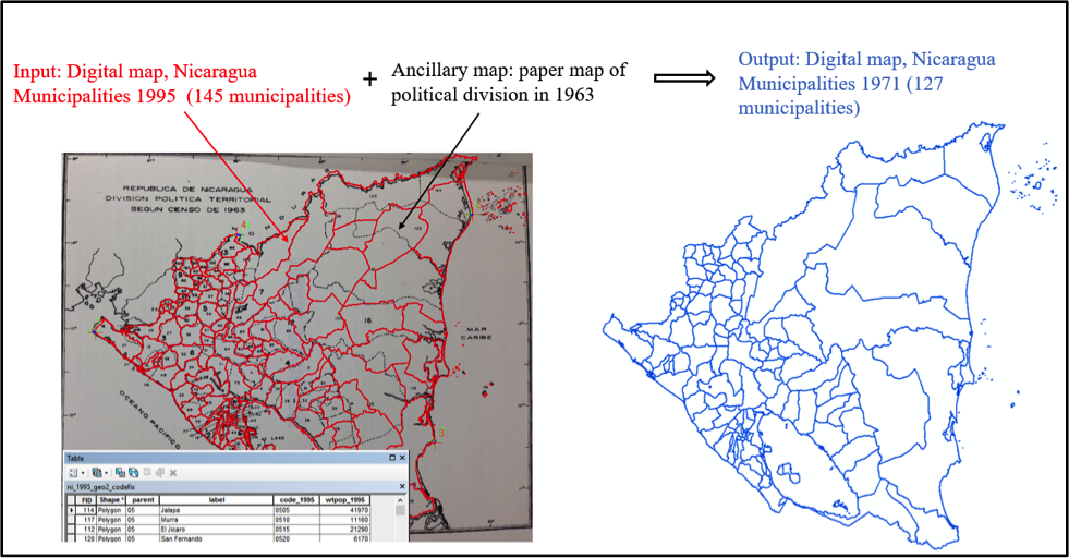
Figure 1. Mapping the administrative divisions of Nicaragua in 1971.
The image above shows 1995 municipalities overlaid on the 1963 scanned image. Note that boundaries from paper maps are usually not as accurate (or detailed) as in digital form. Some of the most common boundary changes occur when two or more municipalities merge to form a new one; a municipality gets split into several units; or when a municipality acquires area from another municipality. Based on the comparison between the two maps, we edited the 1995 municipality boundaries to recreate the 127 municipalities of Nicaragua in 1971.
Story by Maryia Bakhtsiyarava
PhD Student, Department of Geography, Environment and Society
Graduate Research Assistant, Institute for Social Research and Data Innovation


