
By Natalie Mac Arthur, Senior Research Associate, SHADAC
Thank you to our collaborators at the State Health Access Data Assistance Center (SHADAC) for contributing this blog post; view the original blog on the SHADAC website.
A Public Use Microdata Area (PUMA) is a type of geographic unit created for statistical purposes. PUMAs represent geographic areas with a population size of 100,000–200,000 within a state (PUMAs cannot cross state lines). PUMAs are the smallest level of geography available in American Community Survey (ACS) microdata. They are designed to protect respondent confidentiality while simultaneously allowing analysts to produce estimates for small geographic areas.
Every ten years, the decennial census results are used to redefine ACS PUMA boundaries to account for shifts in population and continue to maintain respondent confidentiality. This process is intended to yield geographic definitions that are meaningful to many stakeholders.
Most recently, new PUMAs were created based on the 2020 Census; these 2020 PUMAs were implemented in the ACS starting in the 2022 data year. Although Public Use Microdata Area components remain consistent to the extent possible, they are updated based on census results and revised criteria. Therefore, they are not directly comparable with PUMAs from any previous ACS data years. For example, the 2020 PUMAs used in the 2022 data year are distinct from the 2010 PUMAs, which were used in the 2012–2021 ACS data years.
The 2020 PUMAs were created based on definitions that include two substantive changes relative to the 2010 PUMAs:
- An increase in the minimum population threshold for the minimum size of partial counties from 2,400 to 10,000. Increasing the population minimum for a PUMA-county part aims to further protect the confidentiality of respondents. However, exceptions are allowed on a case-by-case basis in order to maintain the stability of PUMA definitions (that were based on the previous minimum of 2,400) and due to unique geography.
- Allowing noncontiguous geographic areas. Allowing PUMAs to include noncontiguous geographic areas aims to avoid unnecessarily splitting up demographic groups in order to provide more meaningful data. This change is not intended to create highly fragmented PUMAs.
Other than the two changes listed above, PUMA criteria remained consistent, such as treating 100,000 as a strict minimum population size for PUMAs. The maximum population size for PUMAs can exceed a population of 200,000 in certain instances due to expected population declines or geographic constraints.
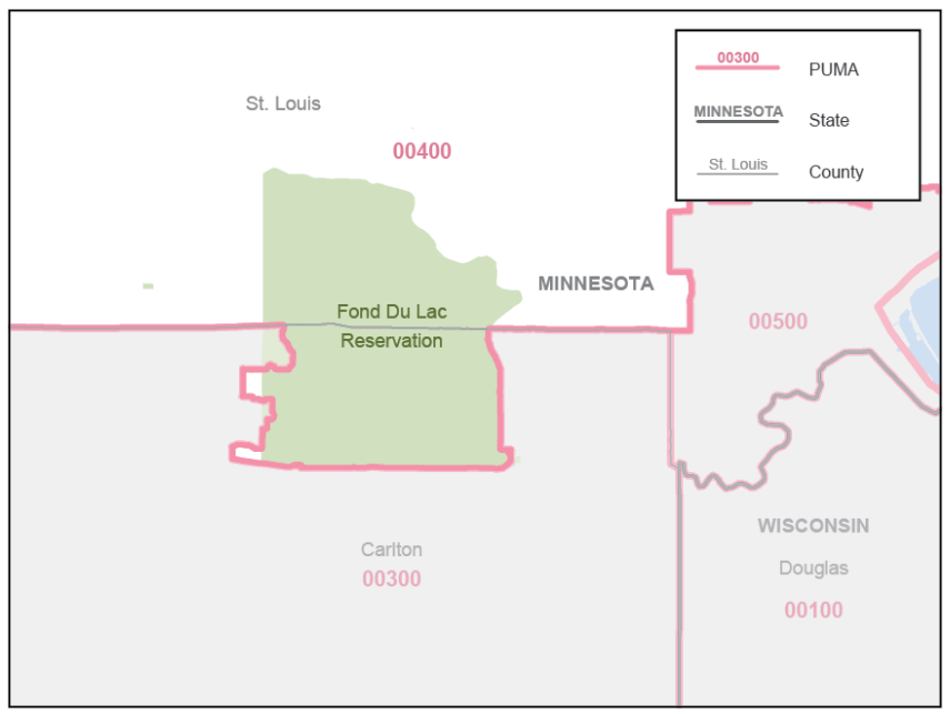
Generally, counties and census tracts are the building block geographies for PUMAs. This maximizes the stability of PUMA boundaries and therefore reduces disclosure risks. Counties may be combined or split as needed, depending on population size. Additionally, PUMAs are designed to avoid unnecessarily splitting metropolitan areas, minor civil divisions (MCDs) with a functional government, and areas of American Indian/Alaska Native (AIAN) and Native Hawaiian people. Carlton County in Minnesota, for example, illustrates that splitting a county was necessary to avoid splitting Fond du Lac reservation into multiple PUMAs (U.S. Census Bureau, 2022).
Figure 1: Minnesota PUMA 00400 Includes Fond du Lac Reservation in Its Entirety
Due to periodic changes in PUMA boundaries, states as a whole are the most granular geographic variable in the ACS microdata that can be compared consistently across all years. However, IPUMS USA offers harmonized geographic variables that greatly expand the options for analyzing ACS data across both time and geography. These variables are less granular than PUMAs, but more granular than states. For example, CONSPUMA and CPUMA0010 combine ACS PUMAs to create consistent geographies that can be compared across multiple decades of PUMA definitions; as of Spring 2024 IPUMS has not yet released consistent PUMA units that include the new 2020 PUMAs. Currently, CITY, COUNTYFIP, and MET2013 allows users to compare cities, counties, and metropolitan areas, respectively, over years 2005-2022.
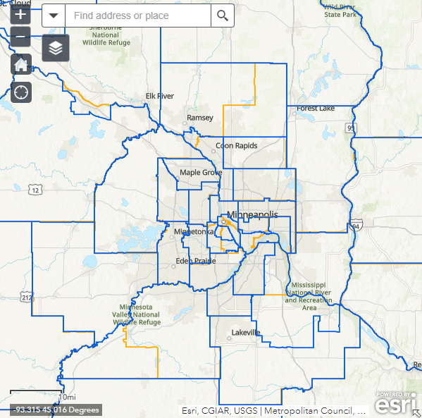
IPUMS USA also provides in-depth geographic resources for ACS data users, including interactive maps of the 2010 and 2020 PUMAs. For example, below is a map of the Twin Cities metropolitan area, Minnesota, showing 2020 PUMAs in blue and 2010 PUMAs in orange (IPUMS USA, 2020). This map illustrates that the updated PUMA criteria resulted in changes to PUMA boundaries in urban areas and some aggregation of PUMAs in more rural areas.
Figure 2: IPUMS USA Map of Twin Cities Metropolitan Area, Minnesota 2010 and 2020 PUMAs
Looking for other data and information from the American Community Survey? Learn more with the following SHADAC products:
2022 ACS Tables: State and County Uninsured Rates
American Indian/Alaska Native (AIAN) and Native Hawaiian and Other Pacific Islander (NHPI) data added to State Health Compare ACS estimates
Explore the Data on State Health Compare
Sources
U.S. Census Bureau. (2022, July 25). Final Criteria for Public Use Microdata Areas for the 2020 Census and the American Community Survey. https://www2.census.gov/geo/pdfs/reference/puma2020/2020PUMA_FinalCriteria.pdf
IPUMS USA (2020). 2020 PUMA Definitions: Web Map of 2010 and 2020 PUMAs. https://usa.ipums.org/usa/volii/pumas20.shtml.