
By Ryan Gavin & Quinn Heimann
IPUMS International launched a new platform that will aid researchers using geospatial contextual data along with IPUMS International census microdata!
What is geospatial contextual data?
Geospatial contextual data describe features of the physical and social environment of a geographic area, and allow users to explore how contextual factors interrelate with individual characteristics and outcomes. For example, in their 2020 paper in Global Environmental Change, Mueller et al. estimated the effects that climate-related variables had on migration in Botswana, Kenya, and Zambia between 1989 and 2011. Often, however, these data are large, complex, and packaged in unfamiliar ways. With this new platform, IPUMS International simplifies the process of identifying and linking contextual data with our robust repository of census microdata.
Geospatial contextual data can vary across space, time, or both and often do not obey administrative boundaries. IPUMS International is unique in offering spatiotemporally harmonized administrative geography variables, which when linked to time-variant contextual data, allow researchers to explore the relationship between social phenomena and temporally-dynamic geospatial data using a consistent spatial footprint.
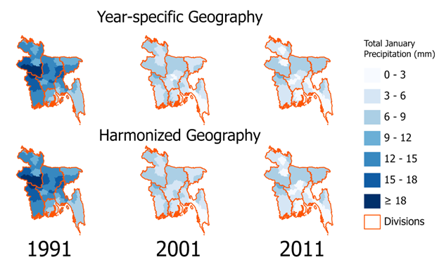
For example, researchers might be interested in studying how changing January precipitation in Bangladesh from 1991-2011 is associated with social or demographic variables. In this case, harmonized geographic variables are ideal because of administrative boundary changes in Bangladesh between 2001 and 2011.
What does IPUMS International currently offer?
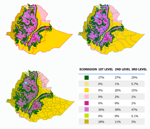
IPUMS International’s new contextual data platform includes a broader discussion about the peculiarities of working with contextual data and tips for selecting appropriate administrative boundary files. Currently there are two variable-specific download pages, with plans to include more variables as the project progresses. These pages highlight the contextual variables: (1) ecoregion–regions of similar geology, vegetation type, climatic zone, and species variation–and (2) precipitation. Each page offers a selection of data sources serving multiple time frames, spatial resolutions, and geographic areas.
The pages also include resources that demonstrate how to join these data to IPUMS geography. The ecoregion page includes a python script that uses World Wildlife Foundation ecoregion data to identify dominant ecoregions at various levels of administrative geography in Ethiopia. Note that while Ethiopia is used as the example, the script itself is self-contained and not country specific. The precipitation page includes a detailed python notebook, which leverages CHIRPS precipitation data and guides users through the entire process of accessing CHIRPS data programmatically and calculating average daily precipitation depth for Bangladesh harmonized geography; this more in-depth tutorial helps researchers visualize the process and provide a scaffold that can be adapted to their own research.
How do I get started?
The best way to begin exploring how contextual data can supplement your IPUMS International research projects is to visit the new contextual data platform and download the ecoregion python script and precipitation instructional notebook.
NOTE: Currently the contextual data platform includes new instructional materials and limited geospatial information. Please email user support with any suggestions at ipums@umn.edu