
By Chris M. Boyd
The IPUMS International Historical Geographic Information System (IHGIS) provides subnational data from agricultural and population and housing censuses from around the world. The agricultural census data cover a wide range of information on agricultural inputs, labor, production, and more, which can be used to explore a variety of research questions. IHGIS data can help understand, for instance, which factors contribute to better crop productivity, including the role of fertilizer use. Researchers have used agricultural census data at the subnational level to analyze the negative relationship between farm size and fertilizer overuse in China1; the relationship between maize yield, farm size and fertilizer and irrigation use in Mexico2; the use of chemical fertilizers in direct market farms in the U.S.3; and the environmental sustainability of using fertilizers, insecticides and pesticides in Pakistan4.
To date, IHGIS has released Agricultural Census tables for ten countries, including seven developing countries in Africa and the Pacific Islands. These seven datasets include information about fertilizer use, though each measures it in a different way (see Table 1). Despite the differences, these data can reveal broad patterns in the use of fertilizer by farmers among these countries.
Table 1. Agricultural Census and Fertilizer Use Variables
| Country | Agricultural Census Year | Administrative Level | Fertilizer use Variable | Fertilizer use at the National Level |
|---|---|---|---|---|
| Pacific Islands | ||||
| Cook Islands | 2011 | Second | Households using fertilizer (%) | 19.6% |
| Tonga | 2001 | Second | Holdings using fertilizer (%) | 13.0% |
| Vanuatu | 2007 | Second | Coffee sub-holdings using fertilizer (%) | 4.8% |
| Africa | ||||
| Madagascar | 2005 | Second | Area (ha) of holdings with organic, inorganic, or mixed fertilizer (%) | 15.3% |
| Togo | 2012 | First | Villages Served by Fertilizer Stores (%) | 4.4% |
| Uganda | 1991 | First | Inorganic fertilizer used (in Kg.) | 522,640 |
| Zambia | 1992 | Second | Holdings applying basal fertilizer (%) | 32.5% |
Subnational data at the first or second administrative level enables us to analyze spatial patterns at a finer scale and consequently to understand intra-country inequalities. Moreover, with the fine-scale data, these spatial patterns can also be linked to environmental data (precipitation or temperature). For instance, Figure 1 shows the differences in fertilizer use across second-level units in Madagascar (panel A) and Zambia (panel B). In both countries, the geographic units with more extensive use of fertilizer are those that include or are around the capital cities of Antananarivo and Lusaka. In Madagascar, there is a clear pattern of more extensive fertilizer use the closer to the country center; the further a geographic unit is from the center of the country, the less likely farmers there are to apply fertilizer. In the case of Zambia, the differences in fertilizer use among geographic units are not as striking as in Madagascar, but geographic units closer to the borders of the country tend to have less fertilizer use, especially in the southwest region.
Figure 1: Fertilizer Use at the Subnational Level
")
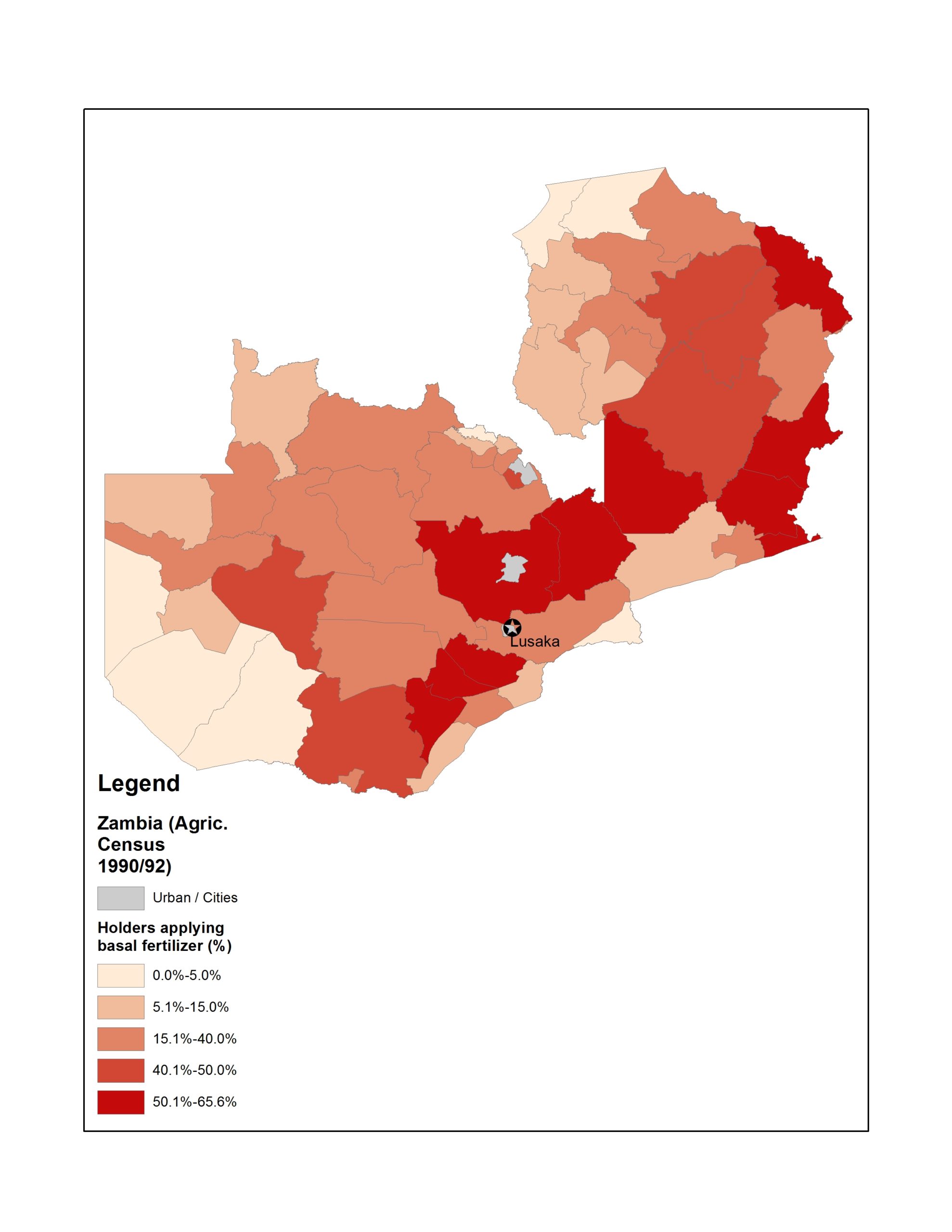
by second administrative level unit (district)
Source: IHGIS
Does the use of fertilizer increase agricultural productivity? Does the pattern of smaller farms having greater productivity (i.e., the inverse farm-size productivity relationship) hold at the subnational level? These questions can be answered with IHGIS data for Zambia for a variety of crops. The data show that districts with higher rates of fertilizer use tend to have higher yields of maize (Fig. 2A) and that districts with smaller average maize farm sizes are not necessarily the ones where fertilizer use is less extensive (Fig. 2B). For districts with average (maize) farm size over 2 hectares, maize productivity increases with size. But for districts with average (maize) farm size below 2 hectares, maize yields are very diverse, ranging from 10.5 to 28.2 (90 Kg. bags per hectare). The relationship between fertilizer use and maize farm size (Fig. 2C) offers a possible answer to the diversity of productivity among maize farms under 2 hectares: fertilizer use in districts with average maize farm size below 2 hectares also have very diverse percentages of fertilizer use. Meanwhile, districts with average maize farm size over 3 hectares have also the highest percentages of fertilizer use.
Figure 2. Zambia (1990/92): Maize Area, Maize Yield, and Basal Fertilizer Use at the second administrative level

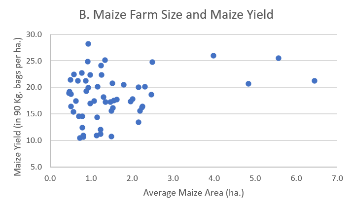
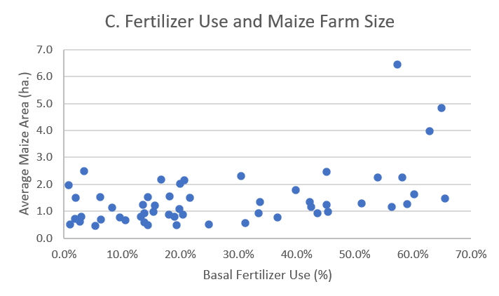
Source: IHGIS
This short example exploring fertilizer use from IHGIS data just shows just a few research areas where the newly IPUMS IHGIS released datasets can be used. We invite you to explore IHGIS data, register for an IHGIS account to stay informed of the latest data releases, and enjoy using IHGIS for your own research!
- Ju, Xiaotang, Baojing Gu, Yiyun Wu, and James N. Galloway. 2016. “Reducing China’s Fertilizer Use by Increasing Farm Size.” Global Environmental Change 41 (November): 26–32. https://doi.org/10.1016/j.gloenvcha.2016.08.005.
- LaFevor, Matthew C., and Nicholas R. Magliocca. 2020. “Farmland Size, Chemical Fertilizers, and Irrigation Management Effects on Maize and Wheat Yield in Mexico.” Journal of Land Use Science 15 (4): 532–46. https://doi.org/10.1080/1747423X.2020.1800849.
- Schoolman, Ethan D. 2019. “Do Direct Market Farms Use Fewer Agricultural Chemicals? Evidence from the US Census of Agriculture.” Renewable Agriculture and Food Systems 34 (5): 415–29. https://doi.org/10.1017/S1742170517000758.
- Zulfiqar, Farhad, and Gopal B. Thapa. 2017. “Agricultural Sustainability Assessment at Provincial Level in Pakistan.” Land Use Policy 68 (November): 492–502. https://doi.org/10.1016/j.landusepol.2017.08.016.